
Make a donation
Gear up for your next adventure:
As an Amazon Associate, this site earns from qualifying purchases at no extra cost to you.
Şanlıurfa topographic map
Click on the map to display elevation.
Make a donation
Gear up for your next adventure:
As an Amazon Associate, this site earns from qualifying purchases at no extra cost to you.
Şanlıurfa
An important consideration in domestic architecture is mahremiyat, which could roughly be translated into English as "privacy" or "intimacy" but which carries stronger implications. This concept is especially important when it comes to relations between men and women – outside the extended family, interaction between men and women is restricted. As a result, traditional Urfa houses are constructed in ways to prevent men outside from viewing the women of the household. For example, doors facing each other, windows facing the street, and significant differences in roof elevation are all avoided.
Make a donation
Gear up for your next adventure:
As an Amazon Associate, this site earns from qualifying purchases at no extra cost to you.
About this map
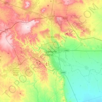
Name: Şanlıurfa topographic map, elevation, terrain.
Average elevation: 623 m
Minimum elevation: 387 m
Maximum elevation: 953 m
Make a donation
Gear up for your next adventure:
As an Amazon Associate, this site earns from qualifying purchases at no extra cost to you.