Geolocate

Vinkovci topographic map

Click on the map to display elevation.

Vinkovci

Vinkovci is located in the eastern part of the Slavonia region, 19 km (12 mi) southwest of Vukovar, 24 km (15 mi) north of Županja and 43 km (27 mi) south of Osijek. The city lies in a flatland on the Bosut river, at an elevation of approx. 90 metres (300 ft), and has a mild continental climate. Vinkovci is also on the northwestern edge of the smaller subregion of Syrmia.

Wikipedia (CC-BY-SA 3.0)

About this map

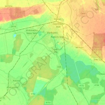
Name: Vinkovci topographic map, elevation, terrain.

Location: Vinkovci, Grad Vinkovci, Vukovar-Srijem County, Croatia (45.20282 18.73496 45.32659 18.84717)

Average elevation: 88 m

Minimum elevation: 68 m

Maximum elevation: 108 m

Other topographic maps

Click on a map to view its topography, its elevation and its terrain.

Babina Greda

Croatia > Vukovar-Srijem County

Average elevation: 84 m

Gunja

Croatia > Vukovar-Srijem County

Average elevation: 84 m

Ilok

Croatia > Vukovar-Srijem County

Average elevation: 119 m

Orolik

Croatia > Vukovar-Srijem County

Average elevation: 96 m

Gear up for your next adventure:

👟Trail Running Shoes - Agile footwear for fast-paced topographic exploration
🦌Outdoor Trail Camera - Monitor wildlife activity near your favorite spots
🧰Emergency Multi-Tool - Compact multi-tool for outdoor survival
🧥Waterproof Jacket - Lightweight rain jackets for hiking and outdoor activities
🥾Waterproof Hiking Boots - Essential footwear for rugged terrain and wet Canadian trails

As an Amazon Associate, this site earns from qualifying purchases at no extra cost to you.