
Make a donation
Gear up for your next adventure:
As an Amazon Associate, this site earns from qualifying purchases at no extra cost to you.
Barnten topographic map
Click on the map to display elevation.
Make a donation
Gear up for your next adventure:
As an Amazon Associate, this site earns from qualifying purchases at no extra cost to you.
Barnten
In Barnten gibt es eine Grundschule. Sie setzt ihren Schwerpunkt auf das Thema Umwelt, wofür sie schon mehrmals ausgezeichnet wurde. Der Höhepunkt der Umweltaktivitäten waren die Maisfeldlabyrinthe im Jahr 2000, 2001 und 2004. Außerdem veranstaltete die Grundschule im Jahr 2007 zum zweiten Mal einen Irischen Abend mit einer irischen Band und seit 2013 findet jährlich das „Krökeln für Kids“ Kickerturnier statt. Finanziell unterstützt wird die Schule dabei von einem eigenen Förderverein, der u. a. eine Erneuerung des Schulhofes durchführen ließ.
Make a donation
Gear up for your next adventure:
As an Amazon Associate, this site earns from qualifying purchases at no extra cost to you.
About this map
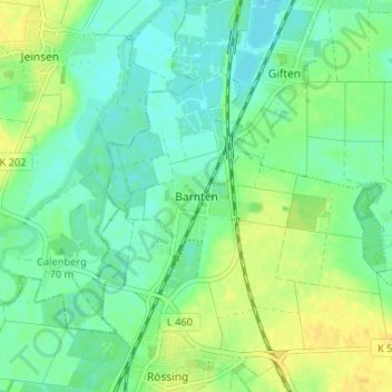
Name: Barnten topographic map, elevation, terrain.
Average elevation: 70 m
Minimum elevation: 60 m
Maximum elevation: 85 m
Make a donation
Gear up for your next adventure:
As an Amazon Associate, this site earns from qualifying purchases at no extra cost to you.