
Peters Township topographic map
Click on the map to display elevation.
About this map
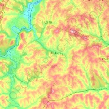
Name: Peters Township topographic map, elevation, terrain.
Average elevation: 336 m
Minimum elevation: 254 m
Maximum elevation: 416 m
Other topographic maps
Click on a map to view its topography, its elevation and its terrain.
Cowden
United States > Pennsylvania > Washington County > Cecil Township > Cecil
Average elevation: 346 m
Strabane
United States > Pennsylvania > Washington County > North Strabane Township
Average elevation: 329 m
Millsboro
United States > Pennsylvania > Washington County > East Bethlehem Township
Average elevation: 308 m
South Strabane
United States > Pennsylvania > Washington County > South Strabane Township
Average elevation: 377 m
Vance
United States > Pennsylvania > Washington County > South Strabane Township
Average elevation: 371 m
Independence
United States > Pennsylvania > Washington County > Independence Township
Average elevation: 357 m
Avella
United States > Pennsylvania > Washington County > Independence Township
Average elevation: 330 m
Lover
United States > Pennsylvania > Washington County > Fallowfield Township
Average elevation: 358 m
Linden
United States > Pennsylvania > Washington County > North Strabane Township
Average elevation: 331 m
Munntown
United States > Pennsylvania > Washington County > Nottingham Township
Average elevation: 351 m
Chambers Mill
United States > Pennsylvania > Washington County > South Franklin Township
Average elevation: 366 m
Enterprise
United States > Pennsylvania > Washington County > South Strabane Township
Average elevation: 334 m
Blainsburg
United States > Pennsylvania > Washington County > West Brownsville
Average elevation: 298 m
Victory Hills
United States > Pennsylvania > Washington County > Carroll Township
Average elevation: 306 m
Mount Wheeler
United States > Pennsylvania > Washington County > North Franklin Township
Average elevation: 382 m