Geolocate

Salinas topographic map

Click on the map to display elevation.

About this map

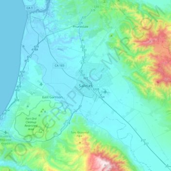
Name: Salinas topographic map, elevation, terrain.

Location: Salinas, Monterey County, California, 93901, United States (36.51441 -121.81504 36.83441 -121.49504)

Average elevation: 147 m

Minimum elevation: -7 m

Maximum elevation: 1,080 m

Gear up for your next adventure:

🥾Trail Running Boots - Durable shoes designed for trail running
🎒Fully Waterproof Backpack - Total protection for photography gear and electronics
🧴Insect Repellent - Protect yourself from bugs during outdoor adventures
🛶Canoe Life Vest - Safety vest for water sports
🧢Hiking Hat - Sun-protective and breathable hats for long treks

As an Amazon Associate, this site earns from qualifying purchases at no extra cost to you.