
Alcalá del Júcar topographic map
Interactive map
Click on the map to display elevation.
About this map
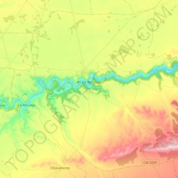
Name: Alcalá del Júcar topographic map, elevation, terrain.
Location: Alcalá del Júcar, Albacete, Castilla-La Mancha, España (39.12382 -1.48731 39.25049 -1.30970)
Average elevation: 699 m
Minimum elevation: 495 m
Maximum elevation: 942 m
Other topographic maps
Click on a map to view its topography, its elevation and its terrain.
Río Júcar
España > Castilla-La Mancha > Alcalá del Júcar
Río Júcar, Alcalá del Júcar, Albacete, Castilla-La Mancha, España
Average elevation: 638 m