
Make a donation
Gear up for your next adventure:
As an Amazon Associate, this site earns from qualifying purchases at no extra cost to you.
Bhondewada topographic map
Click on the map to display elevation.
Make a donation
Gear up for your next adventure:
As an Amazon Associate, this site earns from qualifying purchases at no extra cost to you.
About this map
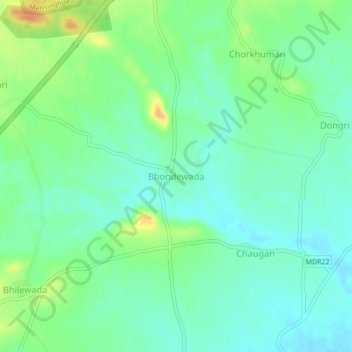
Name: Bhondewada topographic map, elevation, terrain.
Location: Bhondewada, Ramtek Taluka, Nagpur, Maharashtra, 441401, India (21.41648 79.29705 21.45648 79.33705)
Average elevation: 329 m
Minimum elevation: 316 m
Maximum elevation: 356 m
Make a donation
Gear up for your next adventure:
As an Amazon Associate, this site earns from qualifying purchases at no extra cost to you.
Other topographic maps
Click on a map to view its topography, its elevation and its terrain.
Pench (Indira Priyadarsini) National Park/Tiger Reserve
India > Maharashtra > Ramtek Taluka
Average elevation: 485 m
Ramtek Town
India > Maharashtra > Ramtek Taluka
Ramtek is located at 21°24′N 79°20′E / 21.4°N 79.33°E / 21.4; 79.33. It has an average elevation of 345 metres (1131 feet). It is located at a distance of around 50 km from Nagpur. Khindasi lake is one of the important tourist attractions at Ramtek.
Average elevation: 326 m