Geolocate

Kroit topographic map

Click on the map to display elevation.

Kroit

Kroit befindet sich etwa drei Kilometer westlich von Wasserburg und liegt auf einer Höhe von 493 m ü. NHN.

Wikipedia (CC-BY-SA 3.0)

About this map

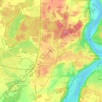
Name: Kroit topographic map, elevation, terrain.

Location: Kroit, Reitmehring, Wasserburg am Inn, Landkreis Rosenheim, Bayern, 83512, Deutschland (48.04392 12.17329 48.08392 12.21329)

Average elevation: 476 m

Minimum elevation: 421 m

Maximum elevation: 520 m

Gear up for your next adventure:

💡LED Headlamp - Hands-free illumination for night hiking and camping
🥾Light Trekking Boots - Supportive boots for multi-day treks
💡Portable Camping Lamp - Rechargeable lamp for campsite lighting
🎒Hiking Daypack - Lightweight and durable backpacks for day trips and excursions
👟Trail Running Shoes - Agile footwear for fast-paced topographic exploration

As an Amazon Associate, this site earns from qualifying purchases at no extra cost to you.