Geolocate

Warragul topographic map

Click on the map to display elevation.

About this map

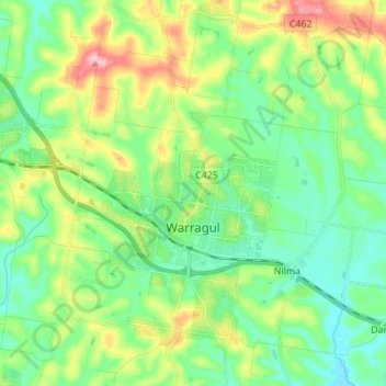
Name: Warragul topographic map, elevation, terrain.

Location: Warragul, Shire of Baw Baw, Victoria, 3820, Australia (-38.20336 145.87550 -38.09530 145.97885)

Average elevation: 136 m

Minimum elevation: 84 m

Maximum elevation: 253 m

Gear up for your next adventure:

Lightweight Camping Tent - Portable shelter optimized for Canadian backcountry camping
🚲Handlebar Phone Mount - View topographic-map.com live while cycling
🎒Hiking Daypack - Lightweight and durable backpacks for day trips and excursions
🧢Beanie Hat - Keep your head warm in cold weather
🧊Portable Cooler - Keep food and drinks cold during outdoor adventures

As an Amazon Associate, this site earns from qualifying purchases at no extra cost to you.