Geolocate

Balinad topographic map

Click on the map to display elevation.

About this map

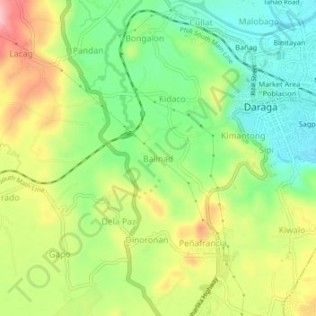
Name: Balinad topographic map, elevation, terrain.

Location: Balinad, Daraga, Albay, Bicol Region, 4501, Philippines (13.12141 123.67873 13.16141 123.71873)

Average elevation: 80 m

Minimum elevation: 13 m

Maximum elevation: 170 m

Gear up for your next adventure:

🛶Waterproof Dry Bags - Keep electronics and clothes dry during river crossings
💧Reusable Water Bottle - Durable water bottles for hydration on trails
🥾Approach Shoes - Shoes designed for climbing approaches and rugged trails
🔋Emergency Crank Radio - Weather alerts and power without needing batteries
🧊Portable Cooler - Keep food and drinks cold during outdoor adventures

As an Amazon Associate, this site earns from qualifying purchases at no extra cost to you.