
Municipality of Ancient Olympia topographic map
Interactive map
Click on the map to display elevation.
About this map
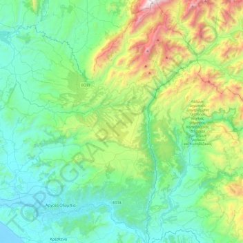
Name: Municipality of Ancient Olympia topographic map, elevation, terrain.
Average elevation: 488 m
Minimum elevation: -6 m
Maximum elevation: 2,112 m
Other topographic maps
Click on a map to view its topography, its elevation and its terrain.
Ancient Olympia
Greece > Peloponnese, Western Greece and the Ionian > Elis Regional Unit
Ancient Olympia, Municipality of Ancient Olympia, Elis Regional Unit, Western Greece, Peloponnese, Western Greece and the Ionian, 270 65, Greece
Average elevation: 99 m
Zacharo
Greece > Peloponnese, Western Greece and the Ionian > Elis Regional Unit > Zacharo Municipal Unit
Zacharo, Zacharo Municipal Unit, Municipality of Zacharo, Elis Regional Unit, Western Greece, Peloponnese, Western Greece and the Ionian, 270 54, Greece
Average elevation: 85 m