
Make a donation
Gear up for your next adventure:
As an Amazon Associate, this site earns from qualifying purchases at no extra cost to you.
Garrettsville topographic map
Click on the map to display elevation.
Make a donation
Gear up for your next adventure:
As an Amazon Associate, this site earns from qualifying purchases at no extra cost to you.
About this map
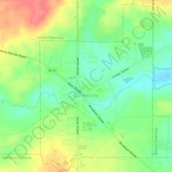
Name: Garrettsville topographic map, elevation, terrain.
Location: Garrettsville, Portage County, Ohio, United States (41.26955 -81.10834 41.30249 -81.07932)
Average elevation: 314 m
Minimum elevation: 283 m
Maximum elevation: 356 m
Make a donation
Gear up for your next adventure:
As an Amazon Associate, this site earns from qualifying purchases at no extra cost to you.
Other topographic maps
Click on a map to view its topography, its elevation and its terrain.
Tom S Cooperrider-Kent Bog State Nature Preserve
United States > Ohio > Portage County
Average elevation: 335 m
Make a donation
Gear up for your next adventure:
As an Amazon Associate, this site earns from qualifying purchases at no extra cost to you.
Nelson Ledges Quarry Park
United States > Ohio > Portage County > Garrettsville
Average elevation: 306 m
Make a donation
Gear up for your next adventure:
As an Amazon Associate, this site earns from qualifying purchases at no extra cost to you.