
Santuario Histórico Bosque de Pómac topographic map
Interactive map
Click on the map to display elevation.
About this map
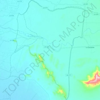
Name: Santuario Histórico Bosque de Pómac topographic map, elevation, terrain.
Average elevation: 76 m
Minimum elevation: 39 m
Maximum elevation: 404 m
Other topographic maps
Click on a map to view its topography, its elevation and its terrain.
Santa Clara
Perú > Lambayeque > Pítipo
Santa Clara, Pítipo, Ferreñafe, Lambayeque, Perú
Average elevation: 91 m
Provincia de Ferreñafe
Perú > Lambayeque > Pítipo
Provincia de Ferreñafe, Pítipo, Ferreñafe, Lambayeque, Perú
Average elevation: 612 m
La Leche
Perú > Lambayeque > Pítipo
La Leche, Pítipo, Ferreñafe, Lambayeque, Perú
Average elevation: 77 m
La Leche
Perú > Lambayeque > Pítipo
La Leche, Pítipo, Ferreñafe, Lambayeque, Perú
Average elevation: 385 m