Geolocate

Moraime topographic map

Click on the map to display elevation.

About this map

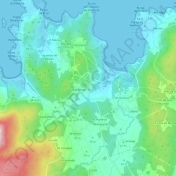
Name: Moraime topographic map, elevation, terrain.

Location: Moraime, Muxía, Fisterra, La Coruña, Galicia, 15125, España (43.06536 -9.21954 43.10536 -9.17954)

Average elevation: 68 m

Minimum elevation: 0 m

Maximum elevation: 299 m

Other topographic maps

Click on a map to view its topography, its elevation and its terrain.

Gear up for your next adventure:

🚲MTB Frame Bag - Carry tools and maps directly on your bicycle frame
🔦LED Headlamp - Hands-free lighting for early morning starts or late finishes
👟Trail Running Shoes - Agile footwear for fast-paced topographic exploration
🎒Backpack Rain Cover - External shield to keep your entire pack dry
Family Camping Tent - Spacious tent suitable for family camping trips

As an Amazon Associate, this site earns from qualifying purchases at no extra cost to you.