
Thank you for supporting this site ❤️
Make a donation
Make a donation
Gear up for your next adventure:
As an Amazon Associate, this site earns from qualifying purchases at no extra cost to you.
Luso topographic map
Click on the map to display elevation.
Thank you for supporting this site ❤️
Make a donation
Make a donation
Gear up for your next adventure:
As an Amazon Associate, this site earns from qualifying purchases at no extra cost to you.
About this map
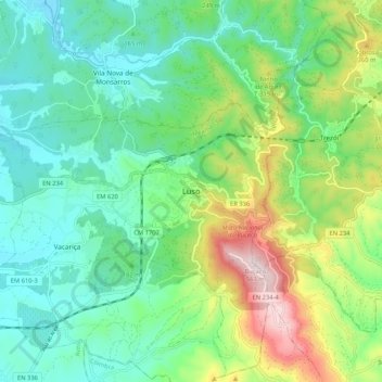
Name: Luso topographic map, elevation, terrain.
Location: Luso, Mealhada, Aveiro, 3050-239, Portugal (40.34391 -8.41603 40.42391 -8.33603)
Average elevation: 201 m
Minimum elevation: 52 m
Maximum elevation: 565 m
Thank you for supporting this site ❤️
Make a donation
Make a donation
Gear up for your next adventure:
As an Amazon Associate, this site earns from qualifying purchases at no extra cost to you.