
Make a donation
Gear up for your next adventure:
As an Amazon Associate, this site earns from qualifying purchases at no extra cost to you.
Seelenberg topographic map
Click on the map to display elevation.
Make a donation
Gear up for your next adventure:
As an Amazon Associate, this site earns from qualifying purchases at no extra cost to you.
About this map
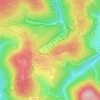
Name: Seelenberg topographic map, elevation, terrain.
Average elevation: 554 m
Minimum elevation: 448 m
Maximum elevation: 660 m
Make a donation
Gear up for your next adventure:
As an Amazon Associate, this site earns from qualifying purchases at no extra cost to you.
Other topographic maps
Click on a map to view its topography, its elevation and its terrain.
Großer Feldberg
Deutschland > Hessen > Hochtaunuskreis > Schmitten im Taunus
Die Angaben zu seiner genauen Höhe liegen je nach Quelle zwischen 878 und 881,5 m ü. NHN Höhe (siehe Abschnitt Berghöhe). Mit einer Prominenz von 670 m (über dem Sattel bei Großen-Buseck nahe Gießen) und einer Dominanz von 101 km (gegen die Dammersfeldkuppe in der Rhön) ist er einer der markantesten…
Average elevation: 716 m