
Thank you for supporting this site ❤️
Make a donation
Make a donation
Gear up for your next adventure:
As an Amazon Associate, this site earns from qualifying purchases at no extra cost to you.
Magoura topographic map
Click on the map to display elevation.
Thank you for supporting this site ❤️
Make a donation
Make a donation
Gear up for your next adventure:
As an Amazon Associate, this site earns from qualifying purchases at no extra cost to you.
About this map
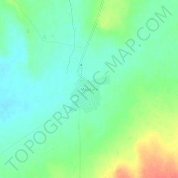
Name: Magoura topographic map, elevation, terrain.
Location: Magoura, El Bouihi, Daïra Sidi Djilali, Tlemcen, Algérie (34.21953 -1.65291 34.25953 -1.61291)
Average elevation: 1,056 m
Minimum elevation: 1,039 m
Maximum elevation: 1,091 m
Thank you for supporting this site ❤️
Make a donation
Make a donation
Gear up for your next adventure:
As an Amazon Associate, this site earns from qualifying purchases at no extra cost to you.