
Make a donation
Gear up for your next adventure:
As an Amazon Associate, this site earns from qualifying purchases at no extra cost to you.
Viepri topographic map
Click on the map to display elevation.
Make a donation
Gear up for your next adventure:
As an Amazon Associate, this site earns from qualifying purchases at no extra cost to you.
Viepri
Viepri è una frazione del comune di Massa Martana (PG), situata a circa 7 km a nord di Massa, 7 km a sud-ovest di Bastardo, ed a 13 km da Todi. Si trova ad un'altitudine di 478 m s.l.m. ed è occupato da 143 abitanti (dati Istat, 2001).
Make a donation
Gear up for your next adventure:
As an Amazon Associate, this site earns from qualifying purchases at no extra cost to you.
About this map
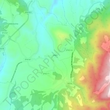
Name: Viepri topographic map, elevation, terrain.
Location: Viepri, Massa Martana, Perugia, Umbria, 06056, Italia (42.80541 12.50205 42.84541 12.54205)
Average elevation: 525 m
Minimum elevation: 358 m
Maximum elevation: 866 m
Make a donation
Gear up for your next adventure:
As an Amazon Associate, this site earns from qualifying purchases at no extra cost to you.