Geolocate

Mokhva topographic map

Click on the map to display elevation.

About this map

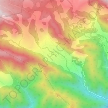
Name: Mokhva topographic map, elevation, terrain.

Location: Mokhva, Sachkhere Municipality, Imereti, Georgia (42.38447 43.30758 42.42447 43.34758)

Average elevation: 948 m

Minimum elevation: 492 m

Maximum elevation: 1,333 m

Other topographic maps

Click on a map to view its topography, its elevation and its terrain.

Sachkhere

Georgia > Imereti > Sachkhere Municipality

Average elevation: 508 m

4000

Georgia > Imereti > Sachkhere Municipality > Durevi

Average elevation: 1,014 m

Gear up for your next adventure:

🔦LED Headtorch - Bright and durable light for night activities
🧭GPS Handheld Device - Reliable GPS navigation for outdoor adventures
🔥Emergency Fire Starter - Reliable ignition source for all weather conditions
🧶550 Survival Paracord - Versatile utility cord for emergency repairs and rigging
🧦Thermal Socks - Warm socks for winter hiking or camping

As an Amazon Associate, this site earns from qualifying purchases at no extra cost to you.