
Make a donation
Gear up for your next adventure:
As an Amazon Associate, this site earns from qualifying purchases at no extra cost to you.
Hampden topographic map
Click on the map to display elevation.
Make a donation
Gear up for your next adventure:
As an Amazon Associate, this site earns from qualifying purchases at no extra cost to you.
Hampden
According to the United States Census Bureau, the town has a total area of 19.6 square miles (51 km2), of which 19.6 square miles (51 km2) is land and 0.05% is water. Hampden is located at the eastern edge of the Connecticut River Valley. Hills rise up to over 1,000 feet (300 m) above sea level, from the valley elevation of 150 to 250 feet (46 to 76 m). The highest peaks are Pine Mt. and Rattlesnake Peak, both at 1,070 feet (330 m). The town has no large bodies of water, but has several brooks which eventually drain into the Connecticut River.
Make a donation
Gear up for your next adventure:
As an Amazon Associate, this site earns from qualifying purchases at no extra cost to you.
About this map
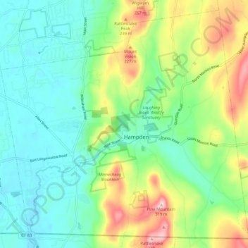
Name: Hampden topographic map, elevation, terrain.
Location: Hampden, Hampden County, Massachusetts, 01036, United States (42.03270 -72.46993 42.10313 -72.36699)
Average elevation: 143 m
Minimum elevation: 60 m
Maximum elevation: 328 m
Make a donation
Gear up for your next adventure:
As an Amazon Associate, this site earns from qualifying purchases at no extra cost to you.