
Richmond topographic map
Interactive map
Click on the map to display elevation.
About this map
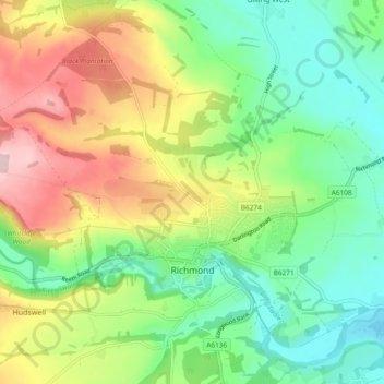
Name: Richmond topographic map, elevation, terrain.
Average elevation: 166 m
Minimum elevation: 70 m
Maximum elevation: 321 m
Other topographic maps
Click on a map to view its topography, its elevation and its terrain.
Marske
United Kingdom > England > North Yorkshire > Richmondshire
Marske, Richmondshire, North Yorkshire, England, United Kingdom
Average elevation: 282 m
Dalton Gates
United Kingdom > England > North Yorkshire > Richmondshire > North Cowton
Dalton Gates, North Cowton, Richmondshire, North Yorkshire, England, DL7 0JU, United Kingdom
Average elevation: 55 m