Geolocate

Canitoan topographic map

Click on the map to display elevation.

About this map

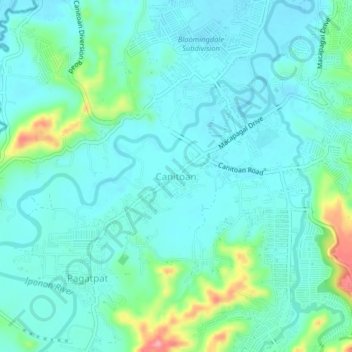
Name: Canitoan topographic map, elevation, terrain.

Location: Canitoan, Cagayan de Oro, Northern Mindanao, 9000, Philippines (8.45242 124.57353 8.49242 124.61353)

Average elevation: 27 m

Minimum elevation: 4 m

Maximum elevation: 116 m

Other topographic maps

Click on a map to view its topography, its elevation and its terrain.

Divisoria Plaza

Philippines > Cagayan de Oro

Average elevation: 11 m

Gaston Park

Philippines > Cagayan de Oro

Average elevation: 13 m

Rodelsa Circle

Philippines > Cagayan de Oro

Average elevation: 19 m

Iponan River

Philippines > Cagayan de Oro

Average elevation: 73 m

Xavier Heights

Philippines > Cagayan de Oro

Average elevation: 96 m

Calaanan Creek

Philippines > Cagayan de Oro

Average elevation: 70 m

Divisoria Plaza

Philippines > Cagayan de Oro

Average elevation: 11 m

Rodelsa Circle

Philippines > Cagayan de Oro

Average elevation: 19 m

Gear up for your next adventure:

🏕️Camping Hammock - Integrated protection for sleeping between trees
🚲Handlebar Phone Mount - View topographic-map.com live while cycling
🛶Waterproof Dry Bags - Keep electronics and clothes dry during river crossings
👖Convertible Hiking Pants - Zip-off legs to adapt to changing weather conditions
🌬️Windproof Camp Stove - Efficient cooking even on exposed mountain peaks

As an Amazon Associate, this site earns from qualifying purchases at no extra cost to you.