Geolocate

Foglianise topographic map

Click on the map to display elevation.

About this map

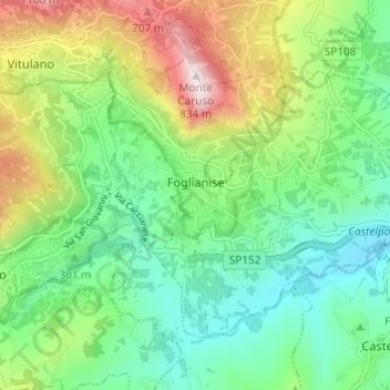
Name: Foglianise topographic map, elevation, terrain.

Location: Foglianise, Benevento, Campania, Italy (41.14190 14.65777 41.17519 14.71851)

Average elevation: 342 m

Minimum elevation: 108 m

Maximum elevation: 824 m

Other topographic maps

Click on a map to view its topography, its elevation and its terrain.

Colle dell'Impiso

Italy > Campania > Benevento > Colle Sannita

Average elevation: 799 m

Ferrarisi

Italy > Campania > Benevento > Casalduni

Average elevation: 251 m

San Lazzaro

Italy > Campania > Benevento > Sant'Agata de' Goti

Average elevation: 321 m

Fonte Coppo La Vigna

Italy > Campania > Benevento > Pietraroja

Average elevation: 1,146 m

Bagnoli

Italy > Campania > Benevento > Sant'Agata de' Goti

Average elevation: 203 m

Gear up for your next adventure:

🥾Mountain Hiking Shoes - Shoes with superior grip for mountainous terrain
🧢Sun Protection Cap - Breathable cap to protect from sun exposure
💧Hydration Pack - Hands-free hydration system for long hikes
🧥Ultralight Puffy Jacket - Maximum warmth that packs down to the size of an orange
🩹Compact First Aid Kit - Pre-packed essentials for common trail injuries

As an Amazon Associate, this site earns from qualifying purchases at no extra cost to you.