Geolocate

Manchester topographic map

Click on the map to display elevation.

About this map

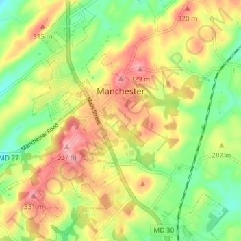
Name: Manchester topographic map, elevation, terrain.

Location: Manchester, Carroll County, Maryland, United States (39.63597 -76.90161 39.68360 -76.87038)

Average elevation: 276 m

Minimum elevation: 221 m

Maximum elevation: 334 m

Other topographic maps

Click on a map to view its topography, its elevation and its terrain.

Finksburg

United States > Maryland > Carroll County

Average elevation: 158 m

Eldersburg

United States > Maryland > Carroll County

Average elevation: 166 m

New Port

United States > Maryland > Carroll County > Woodbine

Average elevation: 188 m

Spring Meadow

United States > Maryland > Carroll County

Average elevation: 219 m

Sugar Valley

United States > Maryland > Carroll County

Average elevation: 236 m

Linden Estates

United States > Maryland > Carroll County

Average elevation: 206 m

Sunset Way

United States > Maryland > Carroll County

Average elevation: 237 m

Finksburg

United States > Maryland > Carroll County

Average elevation: 158 m

Shipley

United States > Maryland > Carroll County

Average elevation: 223 m

Wesley Chapel

United States > Maryland > Carroll County

Average elevation: 205 m

Gist

United States > Maryland > Carroll County

Average elevation: 203 m

Sunset Way

United States > Maryland > Carroll County

Average elevation: 237 m

Woodbine

United States > Maryland > Carroll County

Average elevation: 182 m

Gear up for your next adventure:

🧣Merino Neck Gaiter - Protects against wind, sun, and cold at high altitudes
💡Solar Camping Lamp - Eco-friendly lighting for campsites
🧥Fleece Jacket - Warm and lightweight jacket for layering
🦟Insect Repellent - Keep mosquitoes and black flies away in wooded areas
🧊Portable Cooler - Keep food and drinks cold during outdoor adventures

As an Amazon Associate, this site earns from qualifying purchases at no extra cost to you.