Geolocate

Masikap topographic map

Click on the map to display elevation.

About this map

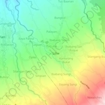
Name: Masikap topographic map, elevation, terrain.

Location: Masikap, Laguna, Calabarzon, 4004, Philippines (14.11057 121.41453 14.15057 121.45453)

Average elevation: 267 m

Minimum elevation: 136 m

Maximum elevation: 466 m

Gear up for your next adventure:

🧢Hiking Hat - Sun-protective and breathable hats for long treks
🧥Softshell Hiking Jacket - The perfect balance of wind protection and breathability
💧Filtered Water Bottle - Safe drinking water on the go
🩹Moleskin Blister Pads - Direct protection for painful foot pressure points
🔋Solar Power Bank - Keep your GPS and devices charged during long outdoor trips

As an Amazon Associate, this site earns from qualifying purchases at no extra cost to you.