Geolocate

Kao topographic map

Click on the map to display elevation.

About this map

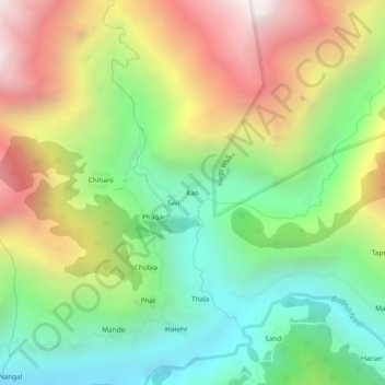
Name: Kao topographic map, elevation, terrain.

Location: Kao, Brahmaur, Chamba, Himachal Pradesh, India (32.45271 76.56958 32.49271 76.60958)

Average elevation: 2,552 m

Minimum elevation: 1,779 m

Maximum elevation: 3,650 m

Other topographic maps

Click on a map to view its topography, its elevation and its terrain.

Gauri Kund

India > Himachal Pradesh > Brahmaur

Average elevation: 4,185 m

Hadsar

India > Himachal Pradesh > Brahmaur

Average elevation: 2,401 m

Bharmour

India > Himachal Pradesh > Brahmaur

Average elevation: 2,204 m

Gear up for your next adventure:

🧥Waterproof Jacket - Lightweight rain jackets for hiking and outdoor activities
🧢Hiking Hat - Sun-protective and breathable hats for long treks
🦶Hiking Shoe Insoles - Added support for high arches and long days on feet
🥾Trail Running Shoes - Lightweight and durable shoes for trail running
🧦Hiking Liner Socks - Thin base layer to prevent friction and blisters

As an Amazon Associate, this site earns from qualifying purchases at no extra cost to you.