
Thank you for supporting this site ❤️
Make a donation
Make a donation
Gear up for your next adventure:
As an Amazon Associate, this site earns from qualifying purchases at no extra cost to you.
Akaoudj topographic map
Click on the map to display elevation.
Thank you for supporting this site ❤️
Make a donation
Make a donation
Gear up for your next adventure:
As an Amazon Associate, this site earns from qualifying purchases at no extra cost to you.
About this map
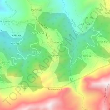
Name: Akaoudj topographic map, elevation, terrain.
Location: Akaoudj, Akbil, Daïra Aïn El Hammam, Tizi Ouzou, 15260, Algérie (36.49045 4.30560 36.53045 4.34560)
Average elevation: 1,031 m
Minimum elevation: 589 m
Maximum elevation: 1,699 m
Thank you for supporting this site ❤️
Make a donation
Make a donation
Gear up for your next adventure:
As an Amazon Associate, this site earns from qualifying purchases at no extra cost to you.
Other topographic maps
Click on a map to view its topography, its elevation and its terrain.