Geolocate

Le Rousset topographic map

Click on the map to display elevation.

About this map

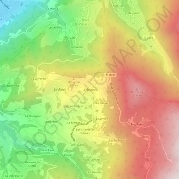
Name: Le Rousset topographic map, elevation, terrain.

Location: Le Rousset, Revel, Grenoble, Isère, Auvergne-Rhône-Alpes, France métropolitaine, 38420, France (45.17479 5.86382 45.21479 5.90382)

Average elevation: 835 m

Minimum elevation: 219 m

Maximum elevation: 1,434 m

Other topographic maps

Click on a map to view its topography, its elevation and its terrain.

38420

France > Auvergne-Rhône-Alpes > Isère > Revel > Les Molettes

Average elevation: 1,038 m

Gear up for your next adventure:

🧣Merino Neck Gaiter - Protects against wind, sun, and cold at high altitudes
🥾Waterproof Hiking Boots - Essential footwear for rugged terrain and wet Canadian trails
🧢Outdoor Cap - Protective cap for sun and rain during hikes
Bushcraft Tarp - Versatile emergency shelter or gear protection
👟Leg Gaiters - Keep debris, mud, and snow out of your boots

As an Amazon Associate, this site earns from qualifying purchases at no extra cost to you.