
Make a donation
Gear up for your next adventure:
As an Amazon Associate, this site earns from qualifying purchases at no extra cost to you.
Mainwangen topographic map
Click on the map to display elevation.
Make a donation
Gear up for your next adventure:
As an Amazon Associate, this site earns from qualifying purchases at no extra cost to you.
Mainwangen
Mainwangen liegt im Nordosten des Hegaus, am Übergang zum Linzgau, etwa anderthalb Kilometer nordwestlich der Mühlinger Ortsmitte, auf einer Höhe von bis zu 681,9 m ü. NHN. Früher, im ausgehenden Mittelalter, wurde diese Landschaft nördlich von Stockach als das „Madach“ bezeichnet.
Make a donation
Gear up for your next adventure:
As an Amazon Associate, this site earns from qualifying purchases at no extra cost to you.
About this map
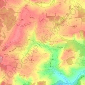
Name: Mainwangen topographic map, elevation, terrain.
Average elevation: 653 m
Minimum elevation: 567 m
Maximum elevation: 699 m
Make a donation
Gear up for your next adventure:
As an Amazon Associate, this site earns from qualifying purchases at no extra cost to you.