Geolocate

Usta Muhammad topographic map

Click on the map to display elevation.

About this map

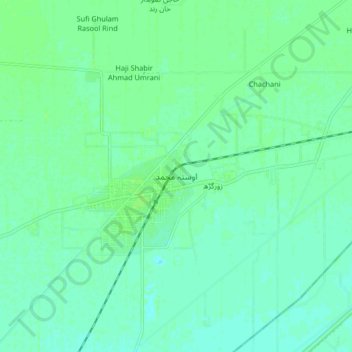
Name: Usta Muhammad topographic map, elevation, terrain.

Location: Usta Muhammad, Balochistan, Pakistan (28.14308 68.01412 28.22308 68.09412)

Average elevation: 53 m

Minimum elevation: 49 m

Maximum elevation: 56 m

Gear up for your next adventure:

🧊Insulated Water Bottle - Keeps drinks cold in summer and prevents freezing in winter
🧼Travel Hand Sanitizer - Keep hands clean when water is scarce
🧤Insulated Winter Gloves - Heavy-duty protection for sub-zero Canadian adventures
🧥Waterproof Pants - Keep dry during rainy hiking conditions
🔭Compact Monocular - One-handed bird watching and trail spotting

As an Amazon Associate, this site earns from qualifying purchases at no extra cost to you.