Geolocate

Reichreit topographic map

Click on the map to display elevation.

About this map

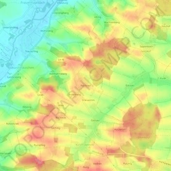
Name: Reichreit topographic map, elevation, terrain.

Location: Reichreit, Vilsbiburg, Landkreis Landshut, Bayern, 84137, Deutschland (48.38390 12.33245 48.42390 12.37245)

Average elevation: 484 m

Minimum elevation: 441 m

Maximum elevation: 523 m

Other topographic maps

Click on a map to view its topography, its elevation and its terrain.

84137

Deutschland > Bayern > Landkreis Landshut > Vilsbiburg > Gaindorf > Berg

Average elevation: 455 m

Gear up for your next adventure:

💧Collapsible Water Bottle - Space-saving water bottle for outdoor activities
🧢Hiking Hat - Sun-protective and breathable hats for long treks
Camping Coffee Maker - Brew fresh coffee anywhere on the topographic map
🍽️Titanium Camping Spork - Ultralight and indestructible eating utensil
🔦UV Flashlight - Detect minerals or specific insects in the dark

As an Amazon Associate, this site earns from qualifying purchases at no extra cost to you.