Geolocate

Maligaon topographic map

Click on the map to display elevation.

About this map

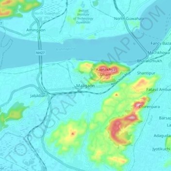
Name: Maligaon topographic map, elevation, terrain.

Location: Maligaon, Guwahati, Kamrup Metropolitan, Assam, 781010, India (26.12005 91.65581 26.20005 91.73581)

Average elevation: 71 m

Minimum elevation: 40 m

Maximum elevation: 285 m

Other topographic maps

Click on a map to view its topography, its elevation and its terrain.

Nehru Park

India > Assam > Guwahati > Guwahati

Average elevation: 53 m

Gear up for your next adventure:

🔦LED Headlamp - Hands-free lighting for early morning starts or late finishes
🦶Hiking Shoe Insoles - Added support for high arches and long days on feet
🕯️Camping Lantern - Illuminates your entire campsite with high-efficiency LEDs
🚲Heavy Duty Bike Lock - Secure your bike at the trailhead or during stops
🧤Thermal Hiking Gloves - Grip-enhanced gloves for cold-weather altitude trekking

As an Amazon Associate, this site earns from qualifying purchases at no extra cost to you.