
Make a donation
Gear up for your next adventure:
As an Amazon Associate, this site earns from qualifying purchases at no extra cost to you.
Yuza topographic map
Click on the map to display elevation.
Make a donation
Gear up for your next adventure:
As an Amazon Associate, this site earns from qualifying purchases at no extra cost to you.
Yuza
Yuza is located in the extreme northwest of Yamagata Prefecture, bordering on Akita Prefecture to the north and the Sea of Japan on the west. It is situated at the northern end of the Shōnai Plain, with the Gekkō River running across the town. Mount Chōkai, which has the second highest elevation in the Tohoku region, is on the northern border. Sandy beaches stretch along the coastline in the southern part of the town, whereas the northern coastline is more rugged due to reefs formed by lava flows from Mt. Chōkai. Part of the town is within the borders of the Chōkai Quasi-National Park.
Make a donation
Gear up for your next adventure:
As an Amazon Associate, this site earns from qualifying purchases at no extra cost to you.
About this map
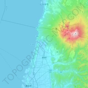
Name: Yuza topographic map, elevation, terrain.
Location: Yuza, Akumi County, Yamagata Prefecture, Japan (38.97586 139.66809 39.14712 140.06720)
Average elevation: 244 m
Minimum elevation: -3 m
Maximum elevation: 2,220 m
Make a donation
Gear up for your next adventure:
As an Amazon Associate, this site earns from qualifying purchases at no extra cost to you.
Other topographic maps
Click on a map to view its topography, its elevation and its terrain.
Mount Chōkai
Japan > Akumi County > Yuza
Mount Chōkai is shared by two municipalities in Akita Prefecture and four municipalities Yamagata Prefecture; however, its peak is located in Yuza, on the Yamagata side of the border. It is therefore the highest peak in Yamagata, and the second highest in the Tōhoku region after Mt. Hiuchigatake (altitude…
Average elevation: 1,808 m