
Make a donation
Gear up for your next adventure:
As an Amazon Associate, this site earns from qualifying purchases at no extra cost to you.
Montagna Grande topographic map
Click on the map to display elevation.
Make a donation
Gear up for your next adventure:
As an Amazon Associate, this site earns from qualifying purchases at no extra cost to you.
About this map
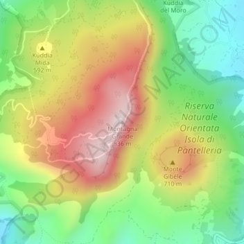
Name: Montagna Grande topographic map, elevation, terrain.
Location: Montagna Grande, Pantelleria, Trapani, Sicilia, 91017, Italia (36.78061 12.00493 36.78071 12.00503)
Average elevation: 521 m
Minimum elevation: 264 m
Maximum elevation: 824 m
Make a donation
Gear up for your next adventure:
As an Amazon Associate, this site earns from qualifying purchases at no extra cost to you.
Other topographic maps
Click on a map to view its topography, its elevation and its terrain.
Isola di Pantelleria
Italia > Sicilia > Trapani > Pantelleria
L'isola raggiunge un'altitudine di 836 m sul livello del mare con la Montagna Grande. Il porto dell'isola permette il collegamento regolare con il porto di Trapani. Pantelleria è dotata di un aeroporto ed è collegata all'Italia continentale con voli di linea, in regime di continuità territoriale.
Average elevation: 137 m
Parco nazionale dell'Isola di Pantelleria
Italia > Sicilia > Trapani > Pantelleria
Average elevation: 169 m