
Make a donation
Gear up for your next adventure:
As an Amazon Associate, this site earns from qualifying purchases at no extra cost to you.
Plage de Ponteil topographic map
Click on the map to display elevation.
Make a donation
Gear up for your next adventure:
As an Amazon Associate, this site earns from qualifying purchases at no extra cost to you.
About this map
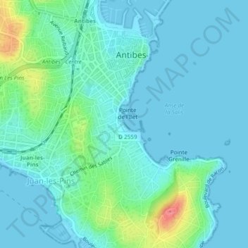
Name: Plage de Ponteil topographic map, elevation, terrain.
Average elevation: 14 m
Minimum elevation: -1 m
Maximum elevation: 74 m
Make a donation
Gear up for your next adventure:
As an Amazon Associate, this site earns from qualifying purchases at no extra cost to you.
Other topographic maps
Click on a map to view its topography, its elevation and its terrain.
Domaine des Trois Moulins de la Valmasque
France > Provence-Alpes-Côte d'Azur > Alpes-Maritimes > Antibes
Average elevation: 123 m
Marineland
France > Provence-Alpes-Côte d'Azur > Alpes-Maritimes > Antibes > Les Groules
Average elevation: 9 m
Jardin de la Pinède
France > Provence-Alpes-Côte d'Azur > Alpes-Maritimes > Antibes
Average elevation: 13 m
Make a donation
Gear up for your next adventure:
As an Amazon Associate, this site earns from qualifying purchases at no extra cost to you.
Jardin René Cassin
France > Provence-Alpes-Côte d'Azur > Alpes-Maritimes > Antibes
Average elevation: 19 m