
Gotha topographic map
Interactive map
Click on the map to display elevation.
About this map
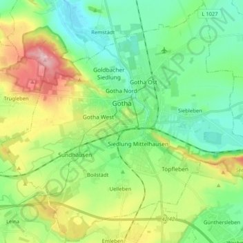
Name: Gotha topographic map, elevation, terrain.
Location: Gotha, Landkreis Gotha, Thüringen, Duitsland (50.89218 10.62230 50.99128 10.78184)
Average elevation: 320 m
Minimum elevation: 263 m
Maximum elevation: 442 m
Other topographic maps
Click on a map to view its topography, its elevation and its terrain.
Tambach-Dietharz
Duitsland > Thüringen > Landkreis Gotha
Tambach-Dietharz, Landkreis Gotha, Thüringen, 99897, Duitsland
Average elevation: 663 m
Friedrichroda
Duitsland > Thüringen > Landkreis Gotha
Friedrichroda, Landkreis Gotha, Thüringen, 99894, Duitsland
Average elevation: 495 m