
Make a donation
Gear up for your next adventure:
As an Amazon Associate, this site earns from qualifying purchases at no extra cost to you.
Sonneberg topographic map
Click on the map to display elevation.
Make a donation
Gear up for your next adventure:
As an Amazon Associate, this site earns from qualifying purchases at no extra cost to you.
Sonneberg
„Das Schloss Sonneberg wurde auch als Burg Sonneberg oder das Haus zu Sonneberg in alten Dokumenten genannt. Im Jahre 480 erbaute Süne oder Süno, Herzog zu Franken, diese Burg wegen der Thüringischen Einfälle…“ so heißt es auf Seite 64 in der Topographie des Herzoglich-Sachsen-Koburg-Meiningischen Antheils an dem Herzogthum Koburg aus dem Jahre 1781. Diese nicht kritikfreie Darstellung fußt auf der Geschichte der Franken des Abtes Johannes Trithemius aus dem Jahr 1514.
Make a donation
Gear up for your next adventure:
As an Amazon Associate, this site earns from qualifying purchases at no extra cost to you.
About this map
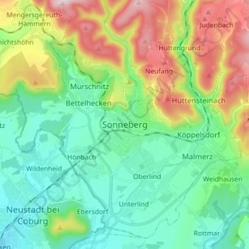
Name: Sonneberg topographic map, elevation, terrain.
Location: Sonneberg, Landkreis Sonneberg, Thüringen, 96515, Deutschland (50.31754 11.12917 50.39754 11.20917)
Average elevation: 445 m
Minimum elevation: 323 m
Maximum elevation: 718 m
Make a donation
Gear up for your next adventure:
As an Amazon Associate, this site earns from qualifying purchases at no extra cost to you.