Geolocate

Ruby Bay topographic map

Click on the map to display elevation.

About this map

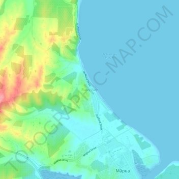
Name: Ruby Bay topographic map, elevation, terrain.

Location: Ruby Bay, Tasman, 7005, New Zealand (-41.25509 173.06635 -41.21509 173.10635)

Average elevation: 23 m

Minimum elevation: 0 m

Maximum elevation: 108 m

Gear up for your next adventure:

📷Outdoor Action Camera - Capture high-elevation views and rugged adventures
🔭Compact Binoculars - Lightweight optics for scouting trails and wildlife
🥘Camping Cookware Set - Compact nesting pots and pans for trail cooking
🧰Survival Kit - Essential gear for emergencies in the wilderness
❄️Traction Ice Cleats - Slip-on spikes for icy trails and winter hiking

As an Amazon Associate, this site earns from qualifying purchases at no extra cost to you.