
Make a donation
Gear up for your next adventure:
As an Amazon Associate, this site earns from qualifying purchases at no extra cost to you.
La Bourboule topographic map
Click on the map to display elevation.
Make a donation
Gear up for your next adventure:
As an Amazon Associate, this site earns from qualifying purchases at no extra cost to you.
About this map
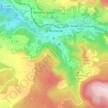
Name: La Bourboule topographic map, elevation, terrain.
Average elevation: 1,077 m
Minimum elevation: 805 m
Maximum elevation: 1,444 m
Make a donation
Gear up for your next adventure:
As an Amazon Associate, this site earns from qualifying purchases at no extra cost to you.
Other topographic maps
Click on a map to view its topography, its elevation and its terrain.
Make a donation
Gear up for your next adventure:
As an Amazon Associate, this site earns from qualifying purchases at no extra cost to you.
La Graissière
France > Auvergne-Rhône-Alpes > Puy-de-Dôme > Saint-Genès-Champanelle
Average elevation: 984 m
Make a donation
Gear up for your next adventure:
As an Amazon Associate, this site earns from qualifying purchases at no extra cost to you.
Soulace
France > Auvergne-Rhône-Alpes > Puy-de-Dôme > Marsac-en-Livradois > Flaittes
Average elevation: 621 m
Les Gicons
France > Auvergne-Rhône-Alpes > Puy-de-Dôme > Montaigut-en-Combraille
Average elevation: 608 m
Beaune-le-Chaud
France > Auvergne-Rhône-Alpes > Puy-de-Dôme > Saint-Genès-Champanelle
Average elevation: 941 m
La Live
France > Auvergne-Rhône-Alpes > Puy-de-Dôme > Glaine-Montaigut > Glaine
Average elevation: 363 m
Make a donation
Gear up for your next adventure:
As an Amazon Associate, this site earns from qualifying purchases at no extra cost to you.
Make a donation
Gear up for your next adventure:
As an Amazon Associate, this site earns from qualifying purchases at no extra cost to you.
Make a donation
Gear up for your next adventure:
As an Amazon Associate, this site earns from qualifying purchases at no extra cost to you.
La Cottas
France > Auvergne-Rhône-Alpes > Puy-de-Dôme > Champétières > Chatelet
Average elevation: 779 m
Andan
France > Auvergne-Rhône-Alpes > Puy-de-Dôme > Saint-Jacques-d'Ambur > Andan
Average elevation: 624 m
Les Chaux
France > Auvergne-Rhône-Alpes > Puy-de-Dôme > Saint-Amant-Roche-Savine > Les Chaux
Average elevation: 901 m
Make a donation
Gear up for your next adventure:
As an Amazon Associate, this site earns from qualifying purchases at no extra cost to you.
Mareuge
France > Auvergne-Rhône-Alpes > Puy-de-Dôme > Le Vernet-Sainte-Marguerite
Average elevation: 1,062 m