Geolocate

Ningde topographic map

Click on the map to display elevation.

About this map

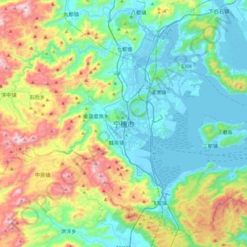
Name: Ningde topographic map, elevation, terrain.

Location: Ningde, Jiaocheng District, Ningde City, Fujian, 352100, China (26.50950 119.38327 26.82950 119.70327)

Average elevation: 303 m

Minimum elevation: -3 m

Maximum elevation: 1,110 m

Gear up for your next adventure:

🧢Sun Protection Cap - Breathable cap to protect from sun exposure
🧦Crew Hiking Socks - Comfortable socks for long-distance hikes
📷Outdoor Action Camera - Capture high-elevation views and rugged adventures
🧭Orienteering Kit - Tools for map reading and navigation in the wild
🏕️Camping Hammock - Integrated protection for sleeping between trees

As an Amazon Associate, this site earns from qualifying purchases at no extra cost to you.