
Make a donation
Gear up for your next adventure:
As an Amazon Associate, this site earns from qualifying purchases at no extra cost to you.
Waldrohrbach topographic map
Click on the map to display elevation.
Make a donation
Gear up for your next adventure:
As an Amazon Associate, this site earns from qualifying purchases at no extra cost to you.
Waldrohrbach
Der Ort liegt am Fuße des Rehbergs, dem mit (577 m ü. NHN) höchsten Berg im deutschen Teil des Wasgaus. Weitere Erhebungen auf der Gemarkung von Waldrohrbach neben dem Rehberg sind der Kleine Hahnstein (451 m ü. NHN), der Große Hahnstein (411 m ü. NHN), die Lebersteine (391 m ü. NHN), der Kahle Knopf (368 m ü. NHN), der Bichelberg (338 m ü. NHN), die Försthöhe (334 m ü. NHN) und die Brandhöhe (319 m ü. NHN).
Make a donation
Gear up for your next adventure:
As an Amazon Associate, this site earns from qualifying purchases at no extra cost to you.
About this map
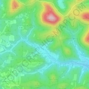
Name: Waldrohrbach topographic map, elevation, terrain.
Average elevation: 321 m
Minimum elevation: 220 m
Maximum elevation: 549 m
Make a donation
Gear up for your next adventure:
As an Amazon Associate, this site earns from qualifying purchases at no extra cost to you.
Other topographic maps
Click on a map to view its topography, its elevation and its terrain.
Rehberg
Deutschland > Rheinland-Pfalz > Landkreis Südliche Weinstraße > Waldrohrbach
Der Rehberg erhebt sich als kegelförmiger Einzelberg im nordöstlichen Wasgau unmittelbar südwestlich über dem Annweilerer Ortsteil Bindersbach. Im Süden wird der Berg begrenzt durch das Tal des Kaiserbachs mit der Gemeinde Waldrohrbach. Er hat eine ovale Grundfläche mit einem Durchmesser von 1 bis 2 km…
Average elevation: 333 m