Geolocate

Taguig topographic map

Click on the map to display elevation.

About this map

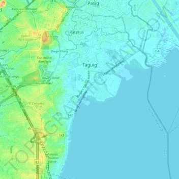
Name: Taguig topographic map, elevation, terrain.

Location: Taguig, Metro Manila, Philippines (14.46494 121.02214 14.56213 121.10852)

Average elevation: 10 m

Minimum elevation: -2 m

Maximum elevation: 59 m

Other topographic maps

Click on a map to view its topography, its elevation and its terrain.

BGC Greenway Park

Philippines > Taguig

Average elevation: 25 m

Taguig River

Philippines > Taguig

Average elevation: 5 m

De Jesus Oval

Philippines > Taguig

Average elevation: 25 m

Taguig River

Philippines > Taguig

Average elevation: 6 m

Tipas River

Philippines > Taguig

Average elevation: 4 m

Taguig River

Philippines > Taguig

Average elevation: 3 m

Gear up for your next adventure:

🧥Waterproof Pants - Keep dry during rainy hiking conditions
🥾Mountaineering Boots - Supportive boots for climbing and high-altitude hiking
🧭GPS Outdoor Watch - Smart watch for navigation and fitness tracking in nature
🥾Trail Running Boots - Durable shoes designed for trail running
🥾Light Hiking Boots - Lightweight and comfortable boots for day hikes

As an Amazon Associate, this site earns from qualifying purchases at no extra cost to you.