
Make a donation
Gear up for your next adventure:
As an Amazon Associate, this site earns from qualifying purchases at no extra cost to you.
Eyne 2600 topographic map
Click on the map to display elevation.
Make a donation
Gear up for your next adventure:
As an Amazon Associate, this site earns from qualifying purchases at no extra cost to you.
About this map
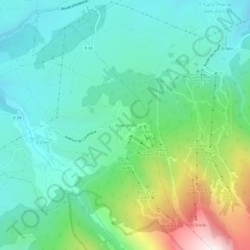
Name: Eyne 2600 topographic map, elevation, terrain.
Average elevation: 1,767 m
Minimum elevation: 1,487 m
Maximum elevation: 2,578 m
Make a donation
Gear up for your next adventure:
As an Amazon Associate, this site earns from qualifying purchases at no extra cost to you.
Other topographic maps
Click on a map to view its topography, its elevation and its terrain.
Réserve naturelle de la Vallée d’Eyne
France > Occitanie > Pyrénées-Orientales > Eyne
Le territoire de la réserve naturelle est dans le département des Pyrénées-Orientales, sur la commune d'Eyne. S'étageant de 1 700 m à 2 800 m d'altitude, il occupe 58 % de la surface de la commune soit 1 177,31 hectares. La partie basse du territoire se trouve à proximité immédiate du village d'Eyne.…
Average elevation: 2,309 m