
Make a donation
Gear up for your next adventure:
As an Amazon Associate, this site earns from qualifying purchases at no extra cost to you.
Doğubayazıt topographic map
Click on the map to display elevation.
Make a donation
Gear up for your next adventure:
As an Amazon Associate, this site earns from qualifying purchases at no extra cost to you.
Doğubayazıt
Doğubayazıt (Kurdish: Bazîd) is a district of Ağrı Province of Turkey, and it is the easternmost district of Turkey, lying near the border with Iran. Its elevation is 1625m and its area is 2,383 km². Doğubayazıt's population in 2010 was 115,354 (up from 73,794 in 1980) of which 69,447 live in the town of Doğubayazıt, the remainder in the surrounding countryside.
Make a donation
Gear up for your next adventure:
As an Amazon Associate, this site earns from qualifying purchases at no extra cost to you.
About this map
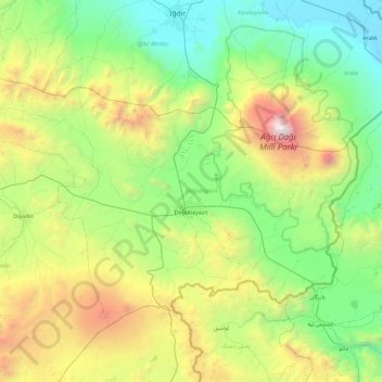
Name: Doğubayazıt topographic map, elevation, terrain.
Location: Doğubayazıt, Ağrı, Eastern Anatolia Region, 04400, Turkey (39.33360 43.55737 39.83868 44.48772)
Average elevation: 1,914 m
Minimum elevation: 813 m
Maximum elevation: 5,067 m
Make a donation
Gear up for your next adventure:
As an Amazon Associate, this site earns from qualifying purchases at no extra cost to you.
Other topographic maps
Click on a map to view its topography, its elevation and its terrain.