Geolocate

Pantalan topographic map

Click on the map to display elevation.

About this map

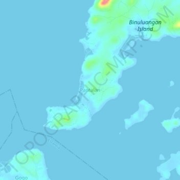
Name: Pantalan topographic map, elevation, terrain.

Location: Pantalan, Carles, Iloilo, Western Visayas, 5017, Philippines (11.47997 123.14532 11.51997 123.18532)

Average elevation: 3 m

Minimum elevation: -1 m

Maximum elevation: 76 m

Gear up for your next adventure:

💧Filtered Water Bottle - Safe drinking water on the go
🥾Light Hiking Boots - Lightweight and comfortable boots for day hikes
🦯Trekking Poles - Reduced impact on joints for steep topographic climbs
🧣Evaporative Cooling Towel - Beat the heat during intense summer climbs
🧥Softshell Jacket - Windproof and breathable jacket for hiking

As an Amazon Associate, this site earns from qualifying purchases at no extra cost to you.