Geolocate

Saint-Dégan topographic map

Interactive map

Click on the map to display elevation.

About this map

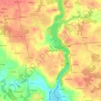
Name: Saint-Dégan topographic map, elevation, terrain.

Location: Saint-Dégan, Brech, Lorient, Morbihan, Bretagne, France métropolitaine, 56400, France (47.68942 -3.01333 47.72942 -2.97333)

Average elevation: 41 m

Minimum elevation: 0 m

Maximum elevation: 64 m

Other topographic maps

Click on a map to view its topography, its elevation and its terrain.

Le Crélin

France > Bretagne > Morbihan > Brech

Le Crélin, Brech, Lorient, Morbihan, Bretagne, France métropolitaine, 56400, France

Average elevation: 31 m

Kerbellec

France > Bretagne > Morbihan > Brech

Kerbellec, Brech, Lorient, Morbihan, Bretagne, France métropolitaine, 56400, France

Average elevation: 31 m

La Villeneuve

France > Bretagne > Morbihan > Brech

La Villeneuve, Brech, Lorient, Morbihan, Bretagne, France métropolitaine, 56400, France

Average elevation: 38 m

Léaulet

France > Bretagne > Morbihan > Brech > Léaulet

Léaulet, Brech, Lorient, Morbihan, Bretagne, France métropolitaine, 56400, France

Average elevation: 29 m

Saint-Guérin

France > Bretagne > Morbihan > Brech

Saint-Guérin, Brech, Lorient, Morbihan, Bretagne, France métropolitaine, 56400, France

Average elevation: 35 m