
Crénénan topographic map
Interactive map
Click on the map to display elevation.
About this map
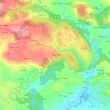
Name: Crénénan topographic map, elevation, terrain.
Average elevation: 184 m
Minimum elevation: 119 m
Maximum elevation: 259 m
Other topographic maps
Click on a map to view its topography, its elevation and its terrain.
Kerlagadec
France > Bretagne > Morbihan > Ploërdut
Kerlagadec, Ploërdut, Pontivy, Morbihan, Bretagne, France métropolitaine, 56160, France
Average elevation: 188 m
Penhoët Braz
France > Bretagne > Morbihan > Ploërdut > Penhoët Braz
Penhoët Braz, Ploërdut, Pontivy, Morbihan, Bretagne, France métropolitaine, 56160, France
Average elevation: 218 m