Geolocate

Noel topographic map

Click on the map to display elevation.

About this map

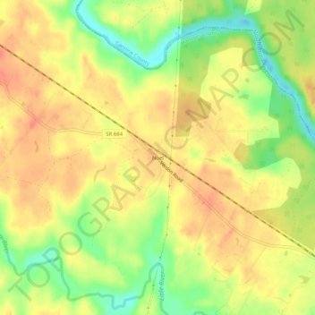
Name: Noel topographic map, elevation, terrain.

Location: Noel, Hanover County, Virginia, United States (37.88458 -77.56415 37.92458 -77.52415)

Average elevation: 70 m

Minimum elevation: 39 m

Maximum elevation: 90 m

Other topographic maps

Click on a map to view its topography, its elevation and its terrain.

Mechanicsville

United States > Virginia > Hanover County > Atlee

Average elevation: 49 m

Ashland

United States > Virginia > Hanover County

Average elevation: 66 m

Ashland

United States > Virginia > Hanover County

Average elevation: 66 m

Gear up for your next adventure:

💧Collapsible Water Bottle - Space-saving water bottle for outdoor activities
🧢Outdoor Visor - Breathable visor for sunny hikes
🏃Hydration Running Vest - Carry water and maps close to your body for speed
🥾Trail Running Boots - Durable shoes designed for trail running
🥫Freeze-Dried Meals - Lightweight, high-calorie nutrition for multi-day treks

As an Amazon Associate, this site earns from qualifying purchases at no extra cost to you.