
Atlanta topographic map
Click on the map to display elevation.
About this map
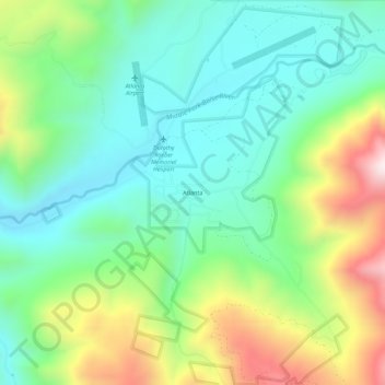
Name: Atlanta topographic map, elevation, terrain.
Location: Atlanta, Elmore County, Idaho, 83601, United States (43.78157 -115.14675 43.82157 -115.10675)
Average elevation: 1,820 m
Minimum elevation: 1,579 m
Maximum elevation: 2,331 m
Other topographic maps
Click on a map to view its topography, its elevation and its terrain.
Mountain Home
United States > Idaho > Elmore County
Mountain Home is located at 43°8′13″N 115°41′40″W / 43.13694°N 115.69444°W / 43.13694; -115.69444 (43.136812, -115.694474), at an elevation of 3,146 feet (959 m) above sea level.
Average elevation: 967 m