Geolocate

Tripoint hydrographique topographic map

Click on the map to display elevation.

About this map

Name: Tripoint hydrographique topographic map, elevation, terrain.

Location: Tripoint hydrographique, Allenc, Mende, Lozère, Occitanie, France métropolitaine, 48190, France (44.55241 3.72389 44.55251 3.72399)

Average elevation: 1,242 m

Minimum elevation: 1,133 m

Maximum elevation: 1,408 m

Other topographic maps

Click on a map to view its topography, its elevation and its terrain.
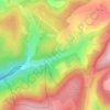
Ruisseau de la Valette

France > Occitanie > Lozère > Allenc

Average elevation: 1,195 m

Gear up for your next adventure:

🥾Trekking Boots - Durable boots for long-distance trekking
🧶550 Survival Paracord - Versatile utility cord for emergency repairs and rigging
📷Outdoor Action Camera - Capture high-elevation views and rugged adventures
🧊Insulated Water Bottle - Keeps drinks cold in summer and prevents freezing in winter
🔋Solar Power Bank - Keep your GPS and devices charged during long outdoor trips

As an Amazon Associate, this site earns from qualifying purchases at no extra cost to you.